Preamble #
Universiti Malaysia Pahang Al-Sultan Abdullah (UMPSA) has been our loyal user since MiTS 1. University lecturers purchase MiTS software usually for teaching purposes, but this case study features something different. We shall see how Professor Madya Ts. Dr. Khairil Azman bin Masri used MiTS to design a total of 450 KM roads.
Job Information #
Client: Pahang State Economic Planning Department
Job Name: Kajian Kebolehlaksanaan Spurline ECRL Negeri Pahang
Project Scope #
The project involved is a preliminary study of the roads that connect to the ECRL railway route, which totals 665 KM and costs RM 50.3 billion. As per the website:
“The overall alignment of the East Coast Rail Link (ECRL) rail network was designed as such to provide a much improved connectivity throughout the East Coast region, as well as connecting it to the West Coast, while at the same time, taking into consideration the potential growth for the industrial, commercial and tourism sectors along the ECRL corridor.”

The ECRL itself is still an ongoing project, and so, the connecting roads are still in the preliminary stage. The client (in this case, Pahang State Economic Planning Department) just wanted to do a feasibility study on road alignments and get a rough estimation on the total costs. Dr. Khairil Azman was the consultant who undertook the job, and he used MiTS for the design purposes.
Google Earth Elevation Points #
At a preliminary stage such as this, the client would not send in actual surveyors to take the elevation measurement due to cost consideration. Google Earth stands out as a choice because one can now get the elevation at a fraction of price as the cost surveyors’ wage, or even for free.
This is exactly what Dr. Khairil was doing; considering that the 450 KM stretch of road is really long (about the distance from Kota Bharu to Kuala Lumpur), the free tier of Google Earth elevation was no longer sufficient. So Dr. Khairil used his credit card to purchase the credits for the point importation. He then used the Google Earth Import function that MiTS has in order to generate the terrain information that serves as a backdrop of his road design.

Alignment Design #
Now that he has the terrain data, the next step is the alignment design – both the horizontal and the vertical alignment. Dr. Khairil obtained the horizontal alignment based on the information given by the planners, which he superimposed as a tracing drawing in MiTS.

Rompin ke Paya Besar
Survey Points: 12,712

For the vertical alignment, he decided on the IP points based on suitable gradients and JKR standards. He then specified the road standards (JKR 2015) and also Road Width element, and let the software churned out the result. Long road notwithstanding, the fact that the road standards are built into the software, and that the design properties that are changeable at spread inputs in batches really made his design lives easier.

CH 51,320 m – CH 52,000 m
Total length: 129.172 km

CH 28,180 m – CH 28,470 m
Total length: 45.69 km

CH 20,760 m – CH 21,260 m
Total length: 28.757 km

CH 8,580 m – CH 9,180 m
Total length: 15.318 km
450 KM in 2 project files #
But 450 KM road, with 27, 858 survey points, is a very huge design undertaking, can MiTS rise to the challenge? We often heard that a lot of road software couldn’t handle even a fraction of that stretch. The real test of a software product is not so much on how fanciful the sales demo is, it’s rather how well it meets day to day challenges, including the challenge of stress testing.
Can MiTS handle it? Well, almost. in the end, Dr Khairil had to break the project into two files, each around 230~ KM for faster speed of operation. Still, being able to handle all the 230 KM of road in one single project file and have the software maintain an acceptable rate of responsiveness is considered quite good by any standards. We actually patted ourselves on the back when we heard that our software can produce all of the outputs, it’s by no means a guaranteed outcome!


Tg. Agas – Lepar Hilir Interchange
CH 0 m – CH 10,400 m

Tg. Agas – Lepar Hilir Interchange
CH 23,200 m – CH 23,600 m

Tg. Agas – Lepar Hilir Interchange
CH 825 m – CH 900 m
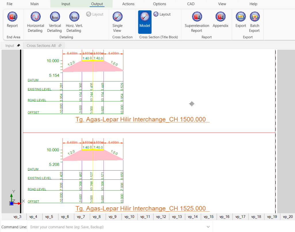
Tg. Agas – Lepar Hilir Interchange
CH 1,500 m & CH 1,525 m
Wish List: Full integration with Google Maps/Earth #
One of the features that Dr. Khairil likes (and which we concur) is the full integration of the software with live maps form Google Maps/Google Earth, akin to Civil 3D Maps. This point is important when it comes to client presentation; most clients are not technical, therefore a living map- instead of just a static image- with engineering design overlaid on top of it is something they can appreciate.
This is something that we look into for the future versions of our product: full map integration with GPS information embedded.

I’m the Benevolent Dictator for Life for MiTS Software cum Editor of this website. Read more here.
You can also contact me at soonhui@mes100.com


