
Fixing Duplicate Survey Points After Import (Verification Warning) #
This guide covers a different workflow from the Survey Points During Import. It applies against survey points that are already in the project (whether they were imported previously, or resolved and committed via the import review panel), and is triggered from a verification warning rather than shown automatically during import.
Where the warning shows up #
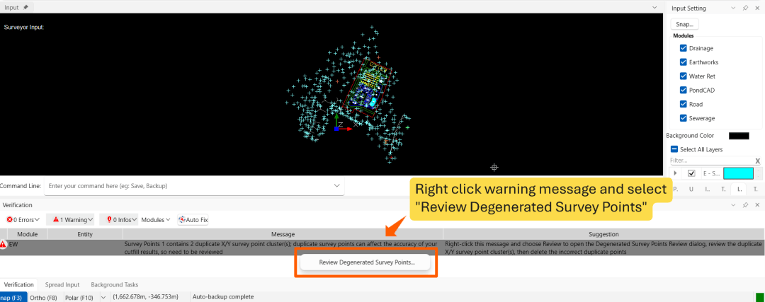
Terrain/mesh calculations continuously check your survey points for problems. If a survey point group has two or more points sharing the same X/Y location (to 6 decimal places), a warning appears in the Verification panel:
“<group name> contains N duplicate X/Y survey point cluster(s); duplicate survey points can affect the accuracy of your cutfill results, so need to be reviewed”
If the Verification panel isn’t currently open, enable it from the View group in the ribbon (Verification).

Note: The “Auto Fix” button in the same panel handles a different set of fixable issues. In Earthwork Module, the autofix includes platform overlaps, non planar platforms and etc. See here for further information. It does not currently support duplicate survey points. To resolve duplicate survey points, refer to verification warning row as described in the next section.
Opening the review dialog #
Right-click the warning row. This opens the Degenerated Survey Points Review dialog.

Using the dialog #
The dialog has two grids and a row of action buttons.
Duplicate X/Y Clusters (top grid) #
Each row represents survey cluster showing X/Y location, survey point count, minimum and maximum Z-elevation, and elevation difference for each cluster.
Click a row and click Highlight Selected Cluster button to highlight the survey cluster in the Input screen. (Double-click the row also perform the same action).

Survey Points in Selected Cluster (bottom grid) #
Every individual point in the currently selected cluster, with a Delete checkbox per row (used by the Delete Selected Points button below), and its X/Y/Z values.

Action buttons #
| Button | Effect |
|---|---|
| Highlight Selected Cluster | Highlights the selected cluster |
| Delete Selected Points | Permanently removes every point whose Delete checkbox is ticked in the bottom grid |
| Keep Highest Z | Deletes every point in the selected cluster except the one with the highest elevation |
| Keep Lowest Z | Deletes every point in the selected cluster except the one with the lowest elevation |
| Refresh | Recomputes the cluster list from the current survey points (useful if you’ve made changes outside this dialog) |
| Close | Closes the dialog |

n/b: You can also select a single point in the bottom grid and press Delete on your keyboard to remove just that one point. Any deletion can be undone using the Undo button (or press Ctrl+Z).
Working through multiple clusters #
The dialog does not need to be closed and reopened after resolving each cluster. Once a cluster is resolved down to a single point, the top grid updates automatically. The next cluster can then be selected and resolved using the same process.
Once every cluster has been resolved, the dialog shows:
“All duplicate X/Y clusters are resolved.”

The dialog can then be closed. The duplicate survey points verification warning is automatically cleared once all duplicate clusters have been resolved.

I’m the Benevolent Dictator for Life for MiTS Software cum Editor of this website. Read more here.
You can also contact me at soonhui@mes100.com


