Some entrepreneuring users might already get their first taste of MITS 2.9 via the Auto Update function, if you haven’t and are still stuck in MiTS 1, do upgrade to MiTS 2 to witness first hand the automagical Auto Update function.
Feature Updates
MiTS 2.9 is a huge update from MiTS 2.8, with over 175 issues addressed and closed. As usual, we would like to express our heartfelt gratitude to our users who send in your feature requests, bug reports and suggestions. It’s your collective effort that makes MiTS software what it is today.
First and most important update for MiTS 2.9 is the MCIntegrator. The most notable change in MCIntegrator is that now we support Surface and Platform Civil Sync, which allows the user to effortlessly transfer their site design from MiTS to Civil 3D. If you ever use Civil 3D for earthwork design, you would realize how unintuitive the tool is, it’s as if you have to actively fight against it to get anything done ( Can’t help, the Civil 3D architecture design guarantees this). Our recent MCIntegrator update will help the user in this regard.

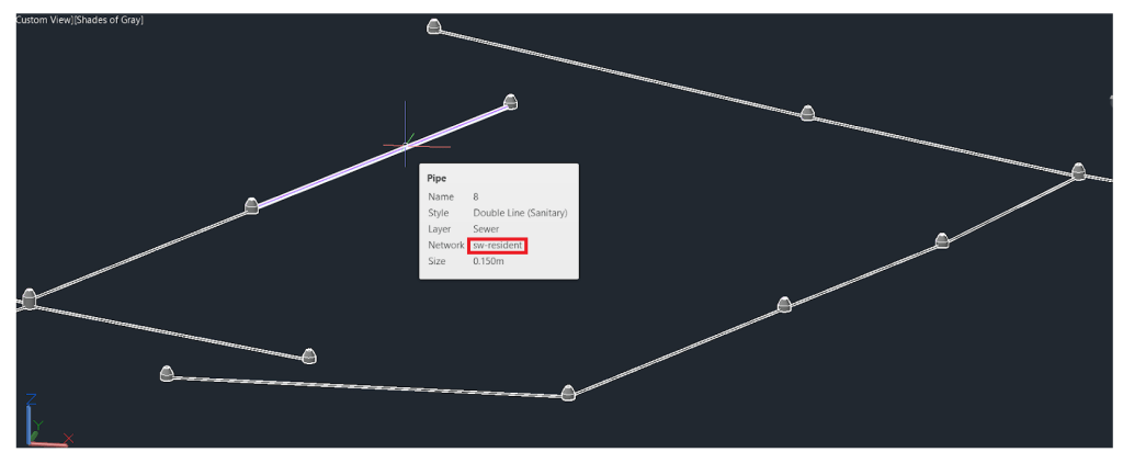
Secondly, MCIntegrator now also supports multiple network synchronization for drainage, sewage and also water reticulation ( or in Civil 3D parlance, pipe networks and pressure pipe networks). This is useful for users who segregate their pipe networks into different systems for better Civil 3D styling needs. MiTS software has been modified so that it also supports multiple Running Networks and Running Pipes for the corresponding mapping to Civil 3D to work.

On the Road Module, we have also implemented the ATJ curve widening table feature, and also Spiral Length overriding feature ( the default is the ATJ table). The details are long and technical, so I’ll just refer to articles for this.
One of the useful features from Earthwork Module is the flexibility in choosing different Meshing methods when it comes to calculating the As-Built volume. If you feel like you want to compute the Original Ground Level using TIN method, but the As-Built surface using TRN method, now you can! For the TRN method, since the quality and the number of elements generated varies greatly with the parameter used, we also implement a verification warning message that warns the user if the number of elements generated is too few; we don’t want the users to shoot themselves in the foot by bad input!
Other notable improvements are the Water reticulation Running Pipe system. The Running Pipe system maps directly to different Pipe Runs in Civil 3D Pressure Pipe. Users can also segregate the schematic plan result and key plan result based on different Running Pipe systems.
We also made improvements on clash analysis so that a clash error will be shown on key plan and long. section when the same type of utility clashes with each other. Previously the clash analysis only worked with the clashing of two different types of utility, ie: it doesn’t work when a drain crosses another drain. Now this is no longer the case.
There are a lot more enhancements and bug fixes which we can’t detail them all here. So we would like to refer users to this page for further information and this page for download.
Knowledge Base and Support
Attentive users will not miss a major change on our website– the whatsapp support number and the Knowledge Base section. Here we just want to mention a few blog posts that we have been working on and which our users found or will find useful:
- Here’s the link to our Knowledge Base, with its two subsections User Manual and Technical Documentation. This link is so important that I hope you can bookmark it.
- How Earthwork cut and fill calculation works in Civil 3D – An exposition on how Civil 3D does Earthwork quantity calculations and why MiTS is a more suitable tool for this purpose
- Civil 3D Fails You – our tale of working with Civil 3D files and all the gotchas. We went through the pain so that you don’t have to.
- When your earthwork Cut and Fill Result is Challenged – a case study with our user on how his client challenged his earthwork quantity result, and managed to convince himself of the accuracy of MiTS quantity result because MiTS provided all the internal and external verification
- Adding values to your clients— a case study on how to use Google Earth import and watershed to do preliminary design.
- How to get API Key for Google Earth Import – Starting from a few months ago you need an API key to do Google Earth Import, here’s how you can do it. Spoiler: Google requires your credit card, but you can use it for free, as long as you are within a certain limit.
- The benchmarking of MiTS 2 earthwork quantity results with Civil 3D – Here’s how you can use our MCIntegrator to transfer the site design from one software to another. And how you can convince yourself that the MiTS 2 earthwork quantity result is accurate.
- How to change the IDF coefficient in Pond Module– You know you can change the IDF coefficient if the built-in values don’t suit your need, right? No, you don’t? Well, we have a guide for this.
- Scale in Cut/Cross Section Drawing in Viewport – So how to interpret all the parameters involved in viewport, like padding and margin? How to get it to work? And how do I know that the software is implementing it correctly? We have prepared an article to guide you.
- MCIntegrator user manual section. This is where we will put our resources regarding MCIntegrator to facilitate your search and references.

I’m the Benevolent Dictator for Life for MiTS Software cum Editor of this website. Read more here.
You can also contact me at soonhui@mes100.com