We are pleased to announce the immediate availability of MiTS 2.5.
The most prominent change in this version is the auto update functionality. If you have MiTS 2.5 or later installed, whenever there is a new version available, the software will prompt you for an update, with the following interface.
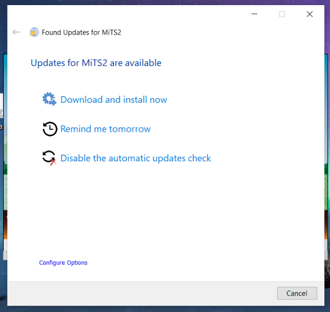
You can then choose to proceed with the installation of the new MiTS software, or defer until later. The program will prompt you again in 3 days time.
This way, MiTS 2 users will be able to take advantage of the latest new feature implementations, enhancements and also bug fixes within the same major version at virtually no cost at all. We want our users to share our growth and progression!
To keep you abreast of the latest development, we also introduce a news panel section at the startup page.
From this panel, you can keep up with our new announcements, blog posts and video tutorials. We publish regularly on modelling tips, our benchmark results and technical articles to help fellow engineers LEARN the software, and the infrastructure design concepts better. We don’t want engineers to just be able to use the software; we also want them to understand and interpret/defend the results from first principles. It’s our goal to make engineers appear as professional as possible.
The next important feature change is that now we support softlock license, the software relies on a virtual license file and not a physical dongle to run. This is a change that we made in direct response to Covid 19 and MCO.
MCIntegrator also receives some updates. We now package the MCIntegrator in the form of MSI/EXE, instead of just a zip file. This would standardize and make the installation/uninstallation process hassle free.
On the general UI level, now we implement a list of functions for keyboard shortcuts. The functions are mimicking AutoCAD functions so that engineers and draftsmen can simply reuse their knowledge instead of relearning new tricks.
For the Earthwork module, if you already have a road level and you want to create platforms that are 300 mm higher than it ( say), now you can do it easily via the Match Elevation function (see section iii). This Match Elevation function is also a handy tool if you want to create slope platforms that connect two different platforms with different heights.
There are a lot more features, enhancements and bug fixes, please refer here for more information. Many thanks to our users who request features, report bugs and ask questions. We take all questions seriously, including a badly asked one; more often than not it only reflects on the inadequacy and the confusion of the software. So please! Don’t hesitate to contact us if you have any questions, we welcome them!
Finally, on training. We would like to inform our users that now we also conduct online training via zoom. Do refer here for more information.

I’m the Benevolent Dictator for Life for MiTS Software cum Editor of this website. Read more here.
You can also contact me at soonhui@mes100.com