- Case 1
- Check on what method is been used
- Check the grid size and distance interval if Grid or End Area method is used
- Check if topsoil is considered in the calculation
- Check if pavement thickness is considered in the calculation
- Check if shrink/swell factor is computed
- Check if the survey points import represents the project terrain correctly
- Check the Alpha Value setting
- Case 2
Case 1 #
What to do if the Earthworks quantity you receive from other parties such as the Quantity Surveyor, contractor or other consultants have some discrepancy from your calculations given the same project.
Check on what method is been used #
MiTS provides three different methods on computing the cut/fill volume, which are Digital Terrain Method (DTM), Grid Method and End Area Method.

The DTM method is a method which compares the original ground level yields from the survey points with the platform surface (surface to surface comparison; Read more here). Grid Method (read here) and End Area Method (read here) are both dependent on the average calculation of the grid size and the cut section interval respectively.
Therefore, if you want to compare between calculations, check what method is being used and to compare between apples to apples, it has to be in the same method.
Check the grid size and distance interval if Grid or End Area method is used #
As mentioned, the Grid and End Area method both are dependent on the grid size/interval used in the calculation. Average calculation of the interval is calculated and as the values change, the output will be changed as well.
If the Grid method is used, check if the size of the grid (ie 5×5 m) and the area covered for the calculation is the same between the projects.

If the End Area method is used, check if the distance interval of the cut section is the same (ie 5 m interval) and area covered for the calculation is also the same.

Check if topsoil is considered in the calculation #
Topsoil is the outermost layer of soil which may be stripped and reused in the construction. Thus, the topsoil calculation will also largely affect the Earthworks computation (related: How to Indicate Topsoil Depth in MITS).

Check if pavement thickness is considered in the calculation #
Pavement thickness may be used in the computation (related: How subgrade/pavement thickness…). When the pavement thickness is considered in the calculation, the computation of the cut/fill volume will be affected, thus the discrepancy, if the comparison between the projects are not using the same inputs.

Check if shrink/swell factor is computed #
Shrink or swell factor may be involved in the Earthworks calculation (read: How does soil swell/shrink factor work in MiTS). Therefore, the comparison must consider the factors as well.

As a sanity check, you can satisfy yourself that the software gives a correct cutfill output by comparing the outputs of different methods. See below for more information:
Check if the survey points import represents the project terrain correctly #
Related to Case Study: Step By Step To Resolving Earthwork Quantity Disputes With Client
It is important for users to import the survey point layer correctly. If there is an existence of other entities in the project that will affect the terrain of your project, you will need to import these entities layer as your survey points too.
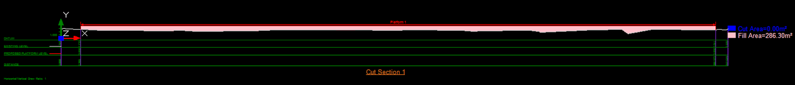
For example, from this drawing, the blue line represents the trenches and the red mark represents the survey points.

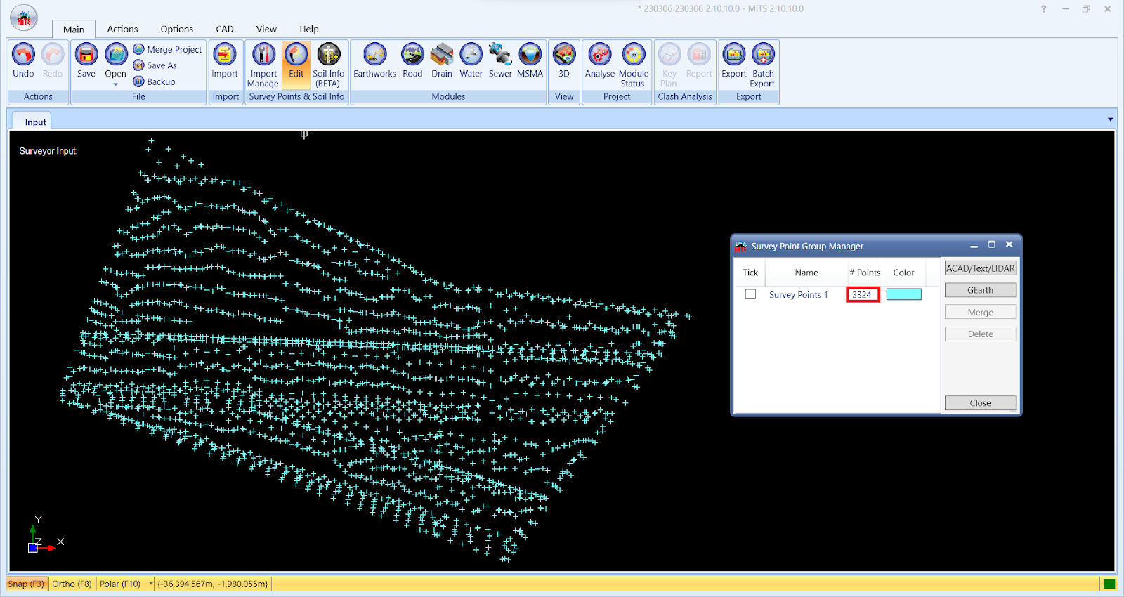
When we only import the red mark layer as our survey points in MiTS, we have only 3324 survey points.
When we create a cut-section, there are no visible trenches and the fill area is 286.30m^2.
Hence, we will also need to import the blue line layer which represents our trenches as the survey points and we have 16384 survey points.

Now, when we view the same cross-section we created earlier, the trenches are now visible and the fill area has increased to 293.94m^2.
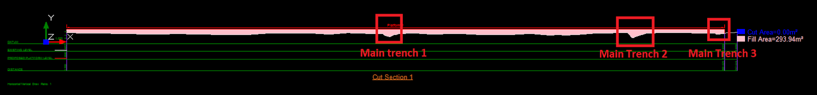
This significant difference for the fill area will highly affect the earthwork computation. Thus, it is important for users to identify what layer they should import as a survey point.
Check the Alpha Value setting #
Users have the flexibility to modify the alpha value, allowing them to decide whether to incorporate or exclude ground levels based on their engineering judgement concerning the required density of surveyor points for precise cut-and-fill calculations. Using a minimum alpha value limits triangulation to areas with survey points while a maximum alpha value extends the coverage to a larger area. If Civil 3D is being used as the benchmark, the alpha value in MiTS should be set until the boundary is about the same as in Civil 3D. You may find the details in this case study.
Case 2 #
Calculation of the Earthworks volume of a project is different by using different methods in MiTS.
You may find a slight discrepancy in the output when computing the Earthworks volume with the three different methods (DTM, Grid and End Area Method). (read more: EW volume comparison between DTM vs Grid Method and End Area method)
However, the difference won’t be much, usually only up 1-2%. The reason is due to the average calculation of the grid size and the cut section interval for Grid and End Area method respectively.
The bigger the size, the higher is the average and leads to the discrepancy in the results. For more accuracy , we will advise you to apply DTM in the calculation, but if you must use the other methods and expect the results to be the same with the DTM results, you have to reduce the interval/size in order to diminish the difference.


